Ages ago, when we knew a little less about the very ground we stand on and the very sky we see, we thought in all its poetic irony that they stretch forever, doomed never to meet. Close enough to see, yet too far to touch and the lucky ones would get to ride off into the sunset, a phrase emphasizing the beauty of the orange splashed sky where the sky and earth supposedly meet. Safe to say, poetically, romantically we have always dreamt of touching the skies, whether its childish fantasies of jumping off of the fluffy clouds or the twinkle in our eyes when we see the dotted night sky. Few of us are lucky enough to even see a glimpse of the star studded milky way away from city lights.
We have been looking at the stars since times long forgotten, we share this fascination with our ancestors so much so that this fascination is what helps us study our own ancestors as well. Archaeoastronomy is a whole field in its own right that interests many.
But if we are moving rotating on our planet’s axis, revolving around the sun, which is revolving around the milky way’s center, in one of its spiral arms spinning around the massive black hole at its center. Oh, and lets not forget our planet’s precession like a spinning top wobbling on its axis. Its a miracle how our brain accounts for all this motion and enables us to even study the night sky?
Surprise surprise we came up with a coordinate system for the night sky, humans are ingenious that way. But before getting into the exact coordinate system that we use to point out telescope to the accelarating galaxies and the revolving planets, lets cover some basics
Celestial Sphere
Because we are on more or less a sphere, so even though if we feel like everything is flat, if we zoom out a bit we are standing on a curved surface and there are stars everywhere around, much like a ball suspended in water – we’re suspended in space.

Figure 1
We imagine all the stars we see in the night sky (well sky in general) lie on this metaphorical sphere. For our measurement purposes we assume that all stars are equidistant from us and lie on the inside of this hollow sphere, much like the planetarium dome. we assume we stand on a stationary surface and its the celestial sphere that rotates from east to west causing the stars to rise and set.
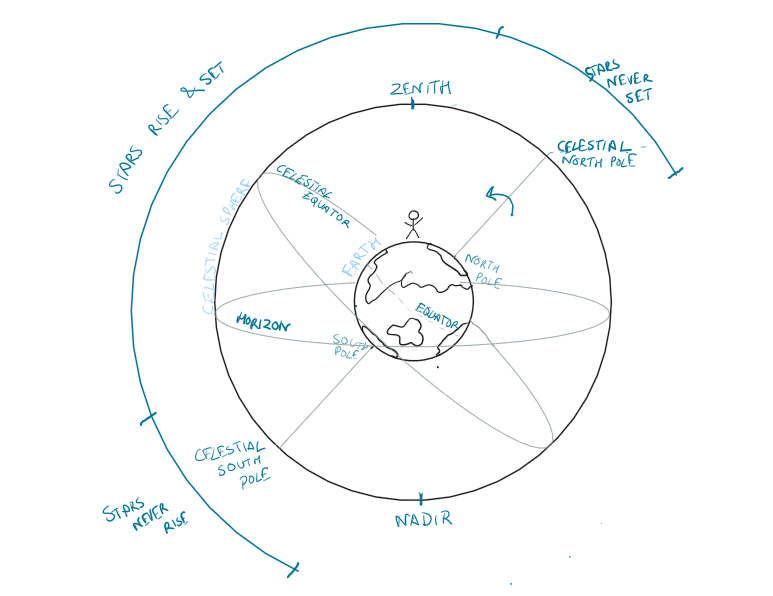
Figure 2
So, this celestial sphere has a north pole that coincides with Earth’s north pole and south pole that coincides with earth’s south pole, the celestial equator could also be seen as an extension of earth’s equatorial plane. Now this system helps us share our coordinates and observations with different observers across earth.
From an observer’s perspective, the the point on the celestial sphere directly above is called Zenith and the point directly below is called Nadir (which we can’t obviously see).
If you were to tell someone what star you see at your zenith they could calculate what latitude would you be at and if you tell them the time they can zone into on your longitude as well (more about that later 🙂 ). As you can see in the picture above, your field of view is constrained (horizon) and stars in your field of view would appear to rise and fall as the celestial sphere rotates. This also explains that depending on where you are, you see the night sky differently.
Motion of the Sky
So how does it look like when you’re standing at different places on earth?
Case 1 – North Pole
If you’re standing on the North Pole that is you’re at 90 degree latitude North (latitude of equator is 0, north pole is 90 degrees and south pole is -90 degrees), the zenith and North Celestial pole with align and directly above you would be the infamous North Pole star or Polaris, brightest star in the night sky.
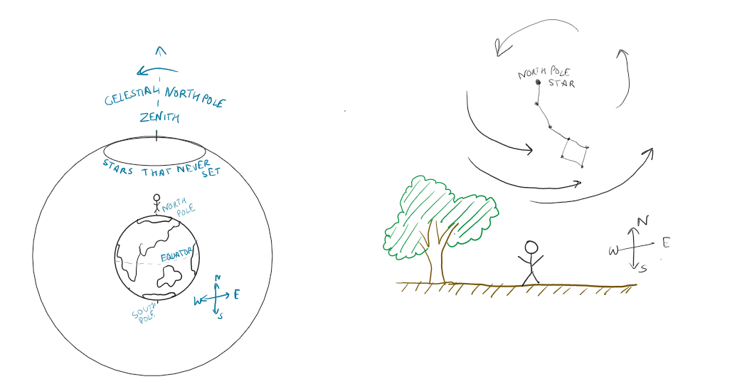
Figure 3
All the stars you would see in the night sky would appear circumpolar that is they will never set, they will be visible to you throughout the night as shown in the right side of the above image. If you take a long exposure shot looking east or west while standing at the north pole it’d look something like this.

Figure 4
Case 2 – Mid Northern latitudes
This is probably what most of us see in North Americas, Europe and Asia. Let’s say if you’re on a 60 degree latitude north, your zenith will be offset from celestial north pole as shown in image 2, in this case, Polaris will appear to you at 30 degrees of your zenith or 60 degrees from your horizon, to show this we’ve isolated the case in a similar way in figure 5 below.

Figure 5
Case 3 – Equator
Now if you’re at the equator, you’d probably see the stars move in vertically straight lines, rising and setting as shown in the figure below.

Figure 6
Summarize
To summarize depending on where you’re observing from earth, this is how stars would appear to move (Figure 7).

Figure 7
Zenith – point directly above your head (based on point of observation)
Nadir – point directly below you (based on point of observation) – not visible
Celestial North Pole, South Pole, Equator – extension of earth’s North Pole, South Pole and Equator
Coordinates
Now you know how the sky would appear to move from where you stand – next comes how do you locate objects
Horizon – Alt-Az
As in the name – Horizon is observer dependent therefore this coordinate system is relative to user’s position on earth.
The coordinate system sets the horizon to be 0 degrees, so the observation latitude and longitude must be known.
Alt or Altitude – Angle above the horizon (How much up)- Angle made from plane of horizon to above (like altitude). Ranges from 0 degrees at horizon to 90 degrees at Zenith. [0,90]
Az or Azimuth – Angle with the horizon (How much on the side) – Locate the north pole from where you stand -the angle measured anti clockwise from local north would be the Azimuth. Ranges from 0 degrees to and not including 360 degrees. [0,360)

Figure 8
Equatorial – RA-Dec
The drawback of alt-az system was that it was based on observer’s position, with equatorial system, it is in reference to the celestial equator, therefore morth standardized, atleast for us earth dwellers.
RA or Right Ascenscion – similar to Azimuth this is the lateral angular distance on the plane of celestial equator, measured eastward from vernal equinox. Vernal equinox is spring equinox (equal length of night and day) which occurs on March 21st and is known as the first point in the constellation of Aries.
Since celestial equator is an extension of earth’s equator, RA could by considered as extension of earth’s longitudes and therefore is also calculated in hours, minutes and seconds and ranges from 0 to 24 hours [0,24) (just like earth’s longitude system). 24 hours represent 360 degrees, therefore 1 hour RA corrosponds to 15 degrees.
Dec or Declination – similar to altitude this is the angular vertical distance of the object from the plane of celestial equator, ranging from -90 degrees (celestial south pole) to +90 degrees (celestial north pole) [-90,+90] with 0 degrees corrosponding to celestial equator just like earth’s latitude system.

Figure 9
There are other coordinate systems used for specific use cases like Galactic (with respect to Milky Way galaxy) to study structure of our own galaxy, supergalactic, ecliptic (with respect to the ecliptic which we’ll discuss in the following article on sun and the solar system).